http://www.bing.com/maps/default.aspx?v ... vl=1&sty=o
So...
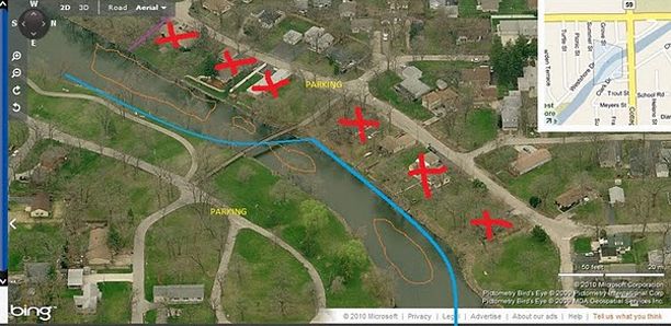
Red X on the map are homes that Shorewood knocked down to make a whole new river walk. There is one house still remaining and this guy is a clown to be careful.
Blue on the map is my wading line. Stay on there in and you will be good to go.
Orange are my holes these are not passable right now only when the river is low. I have tried to pass the 1st hole near the bottom of my screen in low water and have had water come into my wader and I was on my toes
Then second hole holds 2 huge smallies I cant ever catch from the bridge you will see them cruising I have had no luck (they have been there for the past 2 years
The third hole is small but just past the fast water you will find fish.. (Remember Jake)
The last hole some times is a mud fest on my wading track but I do good on that side plus in the summer the home owners would say sh%t. But now they are gone the other side is a hard stone. FOR YOU CARP guys big Grass Carp shoot around like missles here but this area is deep and there is a Purple line when I was out the other day it was like runoff sewer and was flowing.. I caught most my fish in this last hole. WATCH OUT FOR SNAGGS lots of rocks.. I cast a bit up stream and and let it work down.
Fish were caught on Jig and twister White and Pearl.. and the Jig had a gold blade.
The holes start from the bottom of my screen and work on up.\
hope this helps
Again... Such a nice fish