Many years ago I was involved with almost all of the watershed and ecosystem groups in the Chicago area. Over the years I amassed a 2 drawer filing cabinet filled with nothing but river issues. From the big things like dams, to the small things like stenciling sewers to let people know that they drained to the river.
When I shut down my canoe shop in Montgomery in September of 2006, instead of continuing to move all this paper around, I recycled it. Now I rely on Google to find the things that my memory can no longer bring back. When I make my smart ass remark that I've forgotten more about rivers than you'll ever know, there is an element of truth to my smart ass attitude.
One thing I remember is that in the late 90's, 250 breeder sized smallmouth bass were stocked into the East Branch of the DuPage River near Route 56. I vaguely remember it being said they were all in the 14 inch range. For years when I lived in Elmhurst and was fishing the Fox over 100 times a year, I would drive back and forth to the river on Route 56. Every time I drove over that spot I would look down at the East Branch and think to myself that I should go fish it to see if any of those fish were around.
I never did it.
Many years ago I fished the East Branch where it flows through Greene Valley Forest Preserve. The first aerial shows Greene Valley FP. It also shows probably the longest connected group of Forest Preserves and parks that I know of in the area. The map shows the intersection of 75th Street and Route 53 in the north east. Greene Valley actually goes even further north to 63rd Street. Follow the map southwest and you can see all the green, the junction of the East and West Branches of the DuPage River, and the beginning of the main stem of the DuPage. The map ends on the south west at the intersection of Boughton Road and Plainfield/Naperville Road. There is more public land beyond that, but that's a different story.
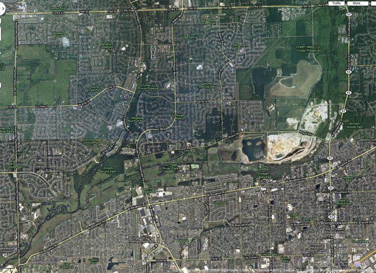
If you've ever driven around the 3 DuPages in the winter you may have noticed that they never freeze. My shortcut to and from work in Hinsdale takes me through the area in the map above twice a day. I've been doing that for almost 3 years. I've never stopped to fish along here. I don't recall ever seeing ice on the rivers as I drive past them. There's a good reason for that.
If you know how to read aerial maps you'll notice two things, treatment plants. A small one off of Route 53 just down from 75th street and a larger one near the southwest intersection of Boughton Road and Plainfield/Naperville Road. I had to look up how many treatment plants are on the DuPages since that is one of the details my memory no longer retains. There are 17 of them. I recall there being more on the East Branch than the others, but I gave up trying to find the number.
The info also said that at normal levels the rivers are made up of 37% treatment plant effluent. I do remember that at lower flows the rivers flow at around 80% effluent. Anyone that has fished around the Montgomery crap plant can see where I'm going with this. During the winter months the Fox crap plant outflow measures 55 degrees. A mile down from it's source in a January many years ago, I was measuring water temps at 45 degrees. A few times a week I pass over the Fox at Orchard Road, many miles down from the crap plant. There is no ice in the river for 20 feet out from the out flow side of the river no matter how cold it is outside.
So picture 17 of them dumping into the narrower, shallower water ways of the DuPages. It would be interesting to take the water temps to see if their is an effect. Since it never freezes, I would imagine the temps will be higher than the Fox or even the Kankakee. Both of which I have seen almost frozen over.
This means that if you want your best chance at catching winter smallies, it doesn't take a scientist to figure out where you should be spending your time to increase your odds dramatically.
As I mentioned, I fished the East Branch through Greene Valley a few times many years ago. I believe it was in January and February. This next map shows where.
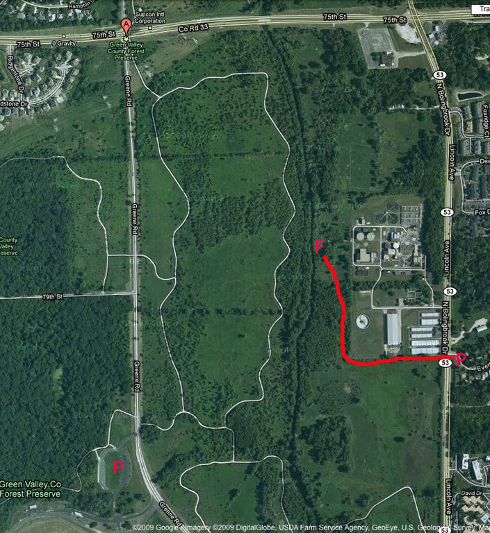
You'll see I marked where I parked and where I fished. Back then I just parked on the side street, hiked along the fence of the storage company and headed for the outflow. This outflow is small. I remember being almost able to jump over it. Now I would probably park on the west side of the river, park in the FP parking lot and hike in.
What I do remember are the fish I caught. If I can find the pictures I'll put them up. Big smallies, not a lot but enough to keep me entertained. Big largemouth that caught me by surprise. Some crappie and bluegills. And the biggest surprise of all, a couple of 18 inch rainbow trout. Out of the East Branch of the DuPage. I think I fished it 3 times that winter and never went back. Now I just drive along it twice a day pondering my prolonged absence.
The next aerial starts to explain things.
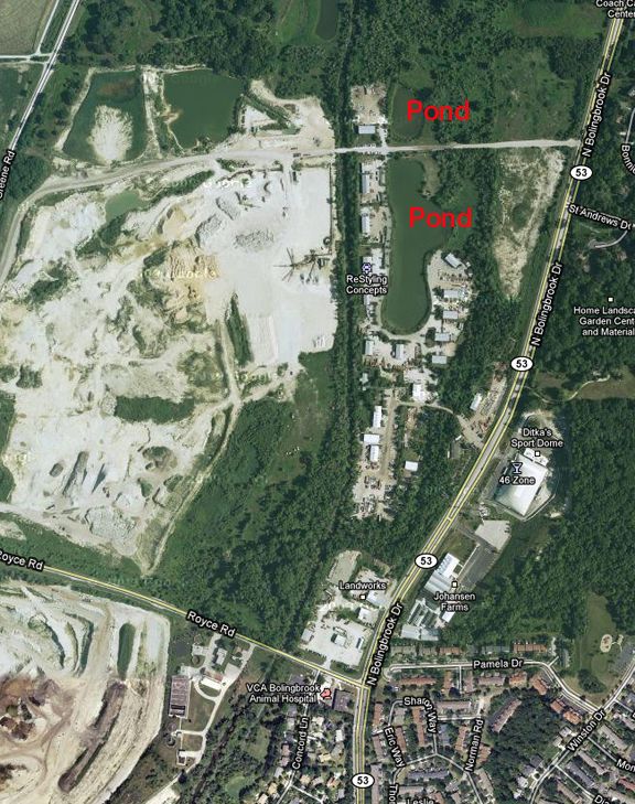
Retention ponds. Asking around and doing some research years ago I found out that when the East Branch floods, it over flows retention ponds not just here, but all up and down the river. Like any new sources of water, fish move in and out of them when they get the chance. These start to explain the source of maybe some of the largemouth and the pan fish. But what about the trout.
That would be the next aerial.
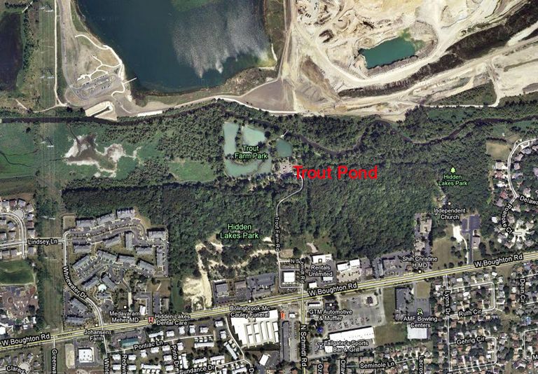
Hidden Lakes Historic Trout Farm in Bolingbrook. I've driven past and seen the sign many times, but have never gone in. A friend says it's pretty well stocked with trout. Apparently it too gets breached by the East Branch at high water. Another friend recently left information regarding this area, including some pretty amazing pictures of trout (see follow up posts below.) I think where I caught the rainbows is a mile north of the trout pond, so they obviously move.
Possibly even down stream into this next stretch.
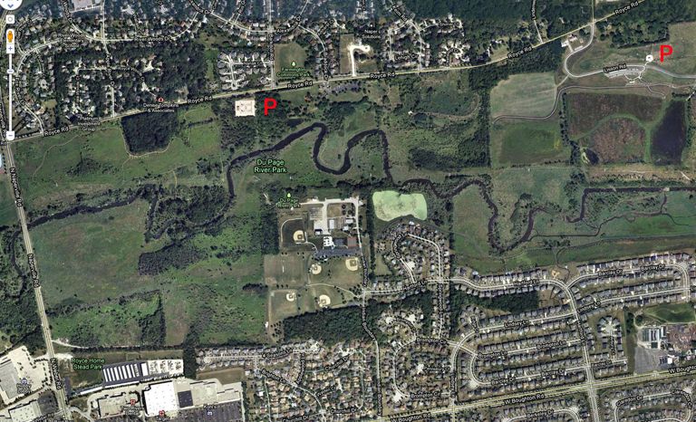
The north side of the river in this stretch is currently undergoing some construction. In the ever increasing desire to put walking paths along rivers, last year they began construction on a trail that starts at the corner of Royce and Naperville Roads in the northwest corner of the above aerial. I can see it winding down into the shallow river valley and making it's way east. At one point it gets too far from the road and disappears, so I don't know where it's going to end. It's still not done, but they look close. Since I drive by here practically every day I've been meaning to stop and fish on my way home from work. Haven't done it yet. This is going to make that decision much easier. There is nothing worse than wading down stream till almost sunset, then having to bush whack your way out to find your car. Nothing like a good path to walk on. Kane County has done a tremendous job with that all up and down the Fox River. Looking forward to putting it to use this year.
You'll notice on the south side that there is a park close to the river in with the homes of the subdivision. Now you know what I go looking for on all bodies of water in the area. A park, even if it is just a playlot next to a creek, is my way in. And you can bet I'm going to take advantage of every one I find.
As we continue down stream . . .
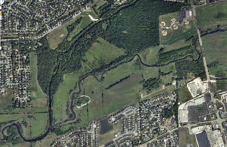
With the East and West Branches of the DuPage coming together in this area, it seems to me someone can spend a month of weekends fishing this area and not get bored. Other than know that the fishing can be pretty good here, I've never gone and checked it out myself. The aerial shows quite a few access points that I can see. The area is a number of different connected parks. I'm going to have to go explore at some point this year. I've only had this on my radar for the past 12 years. It's about time I get to it.
Connected to this is even more as we move down stream.
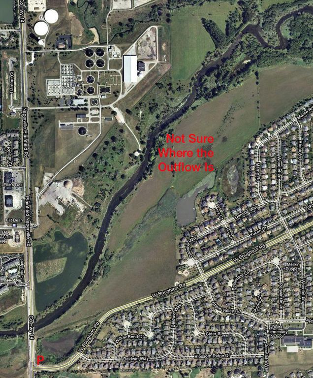
I have no clue where the outflow is for this plant. That will take some exploring to establish. In the lower left hand corner I've marked it as a parking spot. I turn left at this intersection, in order to head south, every day at 5:45 P.M. give or take a few minutes. One time last year as I was waiting for the light, a fly fisherman was parked here and getting ready to head for the river. Thought that was interesting. Didn't think much of it after that. You have to park somewhere to go exploring. Basically here you're just pulling onto the side of the road.
Well, in the next few months I saw the same car parked in that spot 3 more times. If the fishing sucked in this stretch, I would have never seen it again.
Running through the treatment plant you'll see Springbrook Creek. Many years ago I was aware of the details involved with the restoration of Springbrook Prairie a couple of mile upstream from here. I've forgotten them. If you've ever driven along 75th street in this area, you can't miss it. It's one of the few areas that hasn't been paved over.
From here you'll have to Google Bolingbrook and do your own map exploring. You'll see possibly more parks on the north side of the river, west of Plainfield/Naperville Road. In other words, there is no shortage of access.
This whole thing started out as a justification for fishing the main stem of the DuPage River throughout the winter months. Since it never freezes, it must be running warmer than the Kankakee or the Fox. Today I drove over the Fox at the bridge near the end of Silver Springs State Park. You would have to be insane to even try wading that river right now. One big mass of floating ice of various sizes.
The plan is or was to wait till the air temps got above 35 degrees, I won't fish if it's below that, and then go hit the main branch of the DuPage. All that treatment plant outflow has to make a difference. I know just enough spots in Plainfield, Shorewood and Channahon to give this a try. On a side note, Salt Creek where it flow through DuPage County is like and behaves like the DuPages. Never freezes. 12 years ago I would fish below York Road and always walked away catching something. After thinking about it for all these years, may as well go give the DuPages a try.
Problem is, now that I outlined all the details of this area, I may as well start there. I think. Why not?
East, West and Main Branch DuPage Rivers
-
- Posts: 139
- Joined: Thu Jul 16, 2009 5:33 pm
- Type in the middle number (1118): 630
- Location: Joliet IL
- Contact:
Re: East, West and Main Branch DuPage Rivers
Ken you are amazing.. lol.. what a read. I have also talking to a few of my clients and they say they go trout fishing there and they do get out of trout pond.. 2 days ago.. my client in Naperville showed me a pic of his son holding a nice trout.. where on the freaking dupage! about 12 inches... you are a genius. We should get out...soon
- Ken G
- Posts: 2083
- Joined: Tue Jan 15, 2008 11:01 pm
- antispam: No
- Type in the middle number (1118): 1118
- Location: Montgomery, IL
- Contact:
Re: East, West and Main Branch DuPage Rivers
I'm not done with this yet. I told you I was going to give you something to try on the Dupe.
You mentioned going down south further and fishing. That's the theory I'm building on. It's all one big treatment plant outflow. Found another one in Plainfield. Still looking for others down that way. All the others are north.
I would think you could go to your usual spots further down and catch smallies. Just fish slow and out of the current.
Will put this in there . . . took 75th street all the way instead of the Greene Valley shortcut today. No ice over the East Branch. Stop light put me smack dab in the middle of the bridge over the West Branch. Not a piece of ice anywhere.
Got to the Fox near my house. Nothing but slush ice flowing down the whole river and ice in the shore eddies.
I'm busy this and next weekend. If it gets above 35 degrees the one after that, I may have to go. You know the spots better than me, fill me in or come along that day. If you go before that, take a water temp if you can.
-
- Posts: 139
- Joined: Thu Jul 16, 2009 5:33 pm
- Type in the middle number (1118): 630
- Location: Joliet IL
- Contact:
Re: East, West and Main Branch DuPage Rivers
from Caton Farm W Dupage is all clear... south to Channanon is all clear some backwaters I seen driving past were iced up but other then then the Duper is clear of ice
- Ken G
- Posts: 2083
- Joined: Tue Jan 15, 2008 11:01 pm
- antispam: No
- Type in the middle number (1118): 1118
- Location: Montgomery, IL
- Contact:
Re: East, West and Main Branch DuPage Rivers
Drove over it today on I-80. Clear of ice shore to shore.
The fish are there. Hopefully it will be above 35 in two weekends when I have the time. I may have to give this a try.
Ran into Pezdek at Tinley. He's game.
The fish are there. Hopefully it will be above 35 in two weekends when I have the time. I may have to give this a try.
Ran into Pezdek at Tinley. He's game.
- Special Ed
- Poop Ninja
- Posts: 763
- Joined: Mon Sep 28, 2009 12:21 pm
- Type in the middle number (1118): 630
- Location: Oswego, IL
Re: East, West and Main Branch DuPage Rivers
I used to work at Hidden Lakes in Bolingbrook, when I was in High School, it was my summer job. They stock heavy in the Spring and Fall with rainbows, brook trout, brown trout, and golden trout.
I found these fish one Spring just downstream of where the new Whalon Lake parking is, happens to be right across the river from Hidden Lakes. I went back a few times after this and never found more fish.
Last year I took my son to the kid's trout derby. He caught 4 brown trout about 14 inches long on tube jigs tipped with waxies. I thought I had pictures of that, but can't seem to find them.
Directly upstream of Hidden Lakes on the opposite shoreline just before you get to Royce rd. is another WWD. That one I have caught rock bass, crappie, walleye, smallmouth, largemouth, and carp. Easy access if you park at Hidden lakes and walk the bike path.
Anyway, from those maps you will notice the lime green color of Hidden Lakes ponds. They pump in water from Elmhurst Stone's quarry straight into the ponds, all the ponds are connected, and the last pond is piped to outflow directly into the river by the pedestrian bridge you see there on the map. If they didn't drain it it would overfill.
Another area I don't think too many people explore is the water from Seven Bridges Golf Course downstream to 75th st. If you look at that golf course carefully, you will notice that the large water hazard dumps right into the river at Hobson. Did you know they stock that hazard with bass gills and crappie every year to keep the mosquitos and bugs under control? Lets see, the course went into full operation in 1991, so that's almost 20 years of fish living and breeding in that area. I bet there are only a handful of people even tapping into those fish there.
The Duper is a fly-fisherman's paradise. It would take you years to fish that river, and you may never see a handful of other fisherman on the water with you.
-
- Posts: 121
- Joined: Tue Jun 02, 2009 10:10 am
- Type in the middle number (1118): 630
- Location: South Side!
- Contact:
Re: East, West and Main Branch DuPage Rivers
Ken G wrote:Drove over it today on I-80. Clear of ice shore to shore.
The fish are there. Hopefully it will be above 35 in two weekends when I have the time. I may have to give this a try.
Ran into Pezdek at Tinley. He's game.
It was great talking to you Ken, as always. Also had the smallie nazis all over my ass about joining and complimenting me on my great fish last year, etc... so I didn't get to enjoy things as much as I'd like to with one of them following me around constantly telling me that they had people they wanted me to talk to, things I needed to see, etc. Otherwise it was a great time. I didn't really find much of anything I was interested in, with exception of a few soft plastics, etc. but otherwise I enjoyed it. The highlight of me seeing the show was me, you, and my old man shootin the shit. Without a doubt, the best part of the show. Like you said, I'm game to fish. I'm itchin to get out, no matter how cold the water is. I need to wade and fish!!!! Cabin fever is killin me!
- Ken G
- Posts: 2083
- Joined: Tue Jan 15, 2008 11:01 pm
- antispam: No
- Type in the middle number (1118): 1118
- Location: Montgomery, IL
- Contact:
Re: East, West and Main Branch DuPage Rivers
Pezdek, it was great touching base with you and you're dad. I keep bugging the ISA to let me join up. They just laugh. The guys I talk to have no say and the few members who should step down won't ever allow that to happen. I even offered to be their president since no one else in the group wants it. Probably because you'd just be a puppet. Wound up spending a lot of time talking to Bill Chase, haven't had a chance to do that in years. I only go to Tinley to run into people. Otherwise it's just a flea market of stuff I don't need and a bunch of trips I have no interest in taking.
Ed, that is some great info and great looking fish. All the way up on Route 38 there are even more holding ponds that flood in and out. Never stopped there either. With these retention ponds I believe it's a local law that they have to stock them for mosquitoe control. Fish like to move when the opportunity comes up.
I plan on finishing what I started writing above. The whole point was going to be a set to go even further downstream into Plainfield, Shorewood and Channahon to fish winter smallies. The lack of ice pretty much proves it's running warmer than anything else around here, therefore, better odds.
Now I'm wondering if I should just go fish the area we've been talking about.
Would be cool to tie into trout.
Okay Mr. SpecialEd seems to know everything about the area . . . I've waded the stretch near 75th and I've seen one solitary fly fisherman wading at the Naperville Road bridge. I've heard that wading this whole area is easy. Do you concur? How about where the East and West come together, and then a few hundred feet further down stream where Spring Brook cuts through the treatment plant and dumps into the river. I know there are a number of ponds on Spring Brook too. Little dam, creek, little dam, creek.
I bet if you were to try to fish the whole area from 63rd Street to Boughton and Plainfield/Naperville Road in season, you couldn't do it. You'd have to spend at least two trips wandering up the West Branch, maybe three.
I have a cousin whose yard backs up onto the East Branch about a block north of Route 34. St. Joe creek runs along the other side of his house. He has a canoe. I guess I'll have to start making plans.
I hate being a responsible adult. I could probably survive on working 3 days a week at Walmart then having the rest of the time off. But noooo. I had to be given a conscience. And a sense of responsibility. More of the things I wish I wouldn't have inherited from my dad.
- Ken G
- Posts: 2083
- Joined: Tue Jan 15, 2008 11:01 pm
- antispam: No
- Type in the middle number (1118): 1118
- Location: Montgomery, IL
- Contact:
Re: East, West and Main Branch DuPage Rivers
Finsished the post for now. I have a feeling I'll be reading and modifying it a few times in the next few days. I know I have pictures of the times I fished it, but I'll be damned if I can find them. I can't even find the write up I did, which I know I did. That requires reading through 2 years worth of reports adding up to a few hundred pages.
I need an assistant.
- Special Ed
- Poop Ninja
- Posts: 763
- Joined: Mon Sep 28, 2009 12:21 pm
- Type in the middle number (1118): 630
- Location: Oswego, IL
Re: East, West and Main Branch DuPage Rivers
Do I concur about wading the Naperville Rd. bridge area? - NoKen G wrote:Okay Mr. SpecialEd seems to know everything about the area . . . I've waded the stretch near 75th and I've seen one solitary fly fisherman wading at the Naperville Road bridge. I've heard that wading this whole area is easy. Do you concur? How about where the East and West come together, and then a few hundred feet further down stream where Spring Brook cuts through the treatment plant and dumps into the river. I know there are a number of ponds on Spring Brook too. Little dam, creek, little dam, creek.
Reason #1 - I have never fished there.
Reason #2 - Those I have talked to have not found much water worth fishing there.
Now, the area that the East and West come together is a NICE spot. I have fished that area 2 times, both times were more than 10 years ago, but there were bass in every nook and cranny I threw my jigs to. If I remember correctly, there is a nice pool below the "y" and some good boulders that break the current. Hell of a hike though, I know I went mid-summer and got chock full of those damn sticky pricker bush seeds.
Further down from there, I don't know anything about. My explorations on the west branch of the duper went from downtown Naperville all the way through veterans memorial park, through pioneer park, along Washington st. to Weigand riverfront park, through River Mist, Knock Knolls, and down to the East and West merge. I spent limited time on the East branch, fishing from roughly Dupage river park skipping about up to Royce rd. and Rt. 53, then jumping up to Seven Bridges around Hobson rd.
Coincidentally, the biggest river largemouth and the biggest river smallmouth I have ever caught came from the area near Hobson rd.
If anyone fishes Knock Knolls, I suggest going upstream. Somewhere between the Knoch Knolls park and the River Mist backwaters is (I hope) the remnants of a submerged boulder field upstream from a large pool. Me and a buddy spent 4 weeks when we were kids in High School moving boulders from 5 to 40 lbs from the surrounding area to this spot. It was summer break and we needed to keep cool. We'd sneak beers and cigs from the old man, spend the day fishing, catching crayfish, swing into the river on a rope tied to a tree. We thought the hard bottom upstream from the pool would help make it deeper. I haven't been back there since that summer...........